The Best 5 Trailheads For Day Hikes In West Tucson
The Lifestyle Travelers contains affiliate links. If you make a purchase using one of these links, we may receive compensation at no extra cost to you. Read our disclaimer for more information.
LOOKING FOR TRAILHEADS IN WEST TUCSON THAT ARE IDEAL FOR A DAY HIKE?
Tucson, Arizona is a fantastic place for hiking since it has five different mountain ranges surrounding the area. If you find yourself overwhelmed, don’t worry, because this post covers five amazing trailheads that are located specifically in west Tucson.
5 Trailheads in West Tucson for Day Hikes: An Overview
West Tucson is a great location for day hikes. There are a ton of trailheads you can choose from that’ll give you fantastic city and mountainous views while getting that short yet powerful workout in! Here are all the trailheads we’ll be going over today:
Are You Prepared For Your Trip?
5 Trailheads Great for Day Hikes in West Tucson
Although this post is location-specific, the trailheads I’ll be sharing today have plenty of hiking options so that you can customize your day hike however you’d like! Let’s jump in, starting with the trailhead closest to the city center.
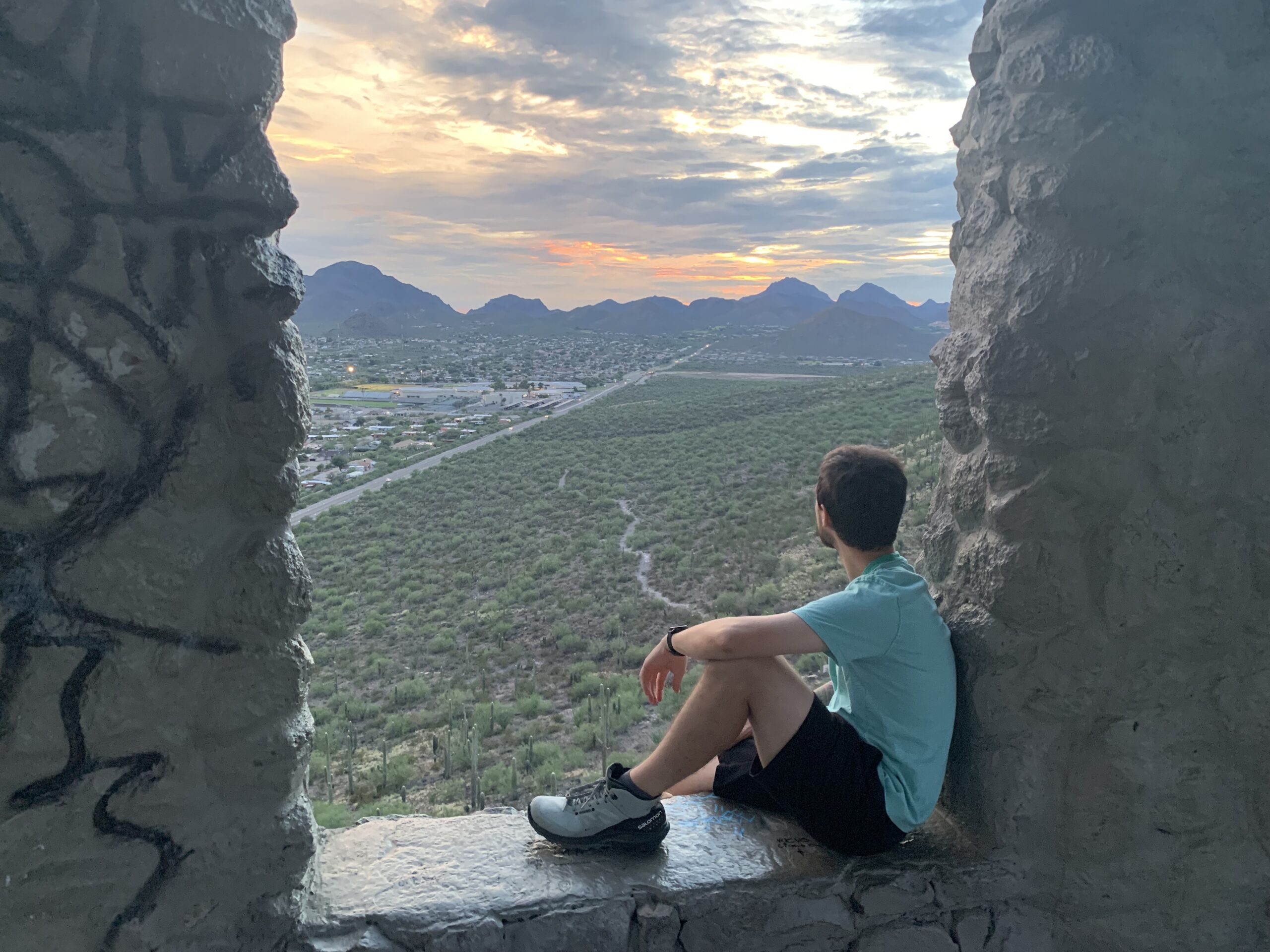
1. Tumamoc Hill
Tumamoc Hill is just a fifteen-minute drive west of the University of Arizona campus. Since it’s located on University property, it’s one of the few trails in the area that is open at night. On the way up, you’ll pass an astronomy research facility that has been open since 1906.

Length: 3.1 miles
Average time to complete: 1 hr, 40 mins
Type of hike: Out & Back
Elevation gain: 3,801 feet
Level of difficulty: Moderate
Dylan and I hiked Tumamoc in August during sunset. The trail can be pretty busy, but the path is wide enough for all the foot traffic. We were also able to see a variety of wildlife on the trail… we saw mule deer and a rattler, so keep your eyes peeled for slithery friends along the way!
The view from the top is breathtaking – you have direct views over the city, but you can also look out on the Tucson mountain range. You’ll also catch a glimpse of Sentinel Peak, also known as the famous “A” mountain in Tucson. It is a paved path that goes up the mountain, so running shoes are perfectly fine for this route. It’s very steep, so make sure you bring enough water with you!
2. Greasewood Park
Located near the Arizona Game and Fish Department, Greasewood Park is the perfect place to go if you want to walk through the desert landscape. Spanning over 152 acres, this park includes a Wilderness and Nature trail where you can learn about the Sonoran desert’s diverse vegetation and wildlife.
This is also a great area for large get-togethers. There are picnic tables, grills, and a water fountain located near the parking lot. There are plenty of trails that you can take around the park, but no matter where you are, you’ll get 360 views of the Tucson mountain ranges.
Consider taking the Greasewood Park trail to immerse yourself in the Sonoran landscape!

Length: 2.9 miles
Average time to complete: 1 hr, 3 mins
Type of hike: Loop
Elevation gain: 213 feet
Level of difficulty: Easy
Greasewood Park is a great place to go if you want to get some exercise outside. It’s a pretty flat area, so this could be a great spot for trail runners who aren’t looking for a ton of elevation gain. I like to visit Greasewood for a nice afternoon stroll during my free time!
3. Painted Hills Park
Painted Hills Park starts to give you the sense that you’re getting away from the city. Located in between residential neighborhoods and Tucson Mountain Park, this park gives you a taste of hiking in the Tucson mountain range. This trailhead offers a handful of hikes, breathtaking views, and a bit more secluded from city life.
On AllTrails, there are currently seven trails listed in the park. Trails range from one to four miles long, with the option of gaining more elevation from two summits. This is a perfect park for short and moderately easy hiking throughout the day. Most of the hikes are loops, so this park is perfect for those who don’t like to see the same thing, twice!

Consider taking one of these hikes…
If you want to get outside for a few hours to get a little elevation in, this is your park. Feel free to bring your dog, because these trails are dog-friendly!
4. Tucson Mountain Park

Tucson Mountain Park is a huge area for hiking. Inside the park you can find Old Tucson, giving you plenty to do during your visit. No matter where you are in the park, you’ll find plenty of hiking options for all levels of hikers. This park is by far one of my favorite trailheads in West Tucson.
Here are some of our favorites…
Tucson Mountain Park also offers plenty of scenic drives along the way if you want to soak up the views on the road. Towards the east entrance, there is a designated area for outside gatherings. There you can find outdoor restrooms, picnic tables, grills, and even hiking trails!
Dylan and I brought our Thanksgiving meal with us to one of these picnic spots, and we couldn’t have enjoyed ourselves more!
5. Saguaro National Park (West)
Many people aren’t aware that Saguaro National Park is split into two locations – the east side and the west side. Saguaro National Park West is located just north of Tucson Mountain Park, so you can access it from the same road. Keep in mind that since it’s a national park, you’ll need to pay an entrance fee of $25 to access the trailhead.

Saguaro National Park is a desert hiker’s dream. You’ll be surrounded by the infamous saguaro cactus wherever you go with an abundance of trails at your disposal (over 165 miles worth). The west side of the national park is great for day hikes.
Some of the most popular trails are…
NEXT UP: The Best Hiking Trails to Wasson Peak in Saguaro National Park
Like Tucson Mountain Park, you can take the Bajada scenic drive if you want to see the park from your car! It’s unpaved, so make sure your car is up for the dirt road!

Trailheads in West Tucson: FAQ’s
Now that we’ve covered five great trailheads in West Tucson, let’s go over some frequently asked questions about hiking in the area!
What is the hardest trail in Tucson?
The hardest trails in Tucson generally are located in the Santa Catalina mountains, in northern Tucson. Some of the harder hikes in the area include hiking up Mount Kimball, Mount Wrightson, and Phoneline Trail. If you’re looking for a challenging hike, head north! West Tucson is better for day hiking.
How long is the Sweetwater trail in Tucson?
The Sweetwater Trail is a 9.3-mile out-and-back to the highest peak in Saguaro National Park West: Wasson Peak. This trail is fantastic for those who are looking for a moderate challenge to complete in one day, and the top provides some excellent views.
Is there good hiking in Tucson, Arizona?
Tucson, Arizona is a hiker’s paradise! Since the city is surrounded by four mountain ranges in all directions, the hiking adventures are endless. The city has trails for all experience levels, making it a great hiking destination.
How many hiking trails are in Tucson?
While it’s hard to gauge the exact number of hiking trails in Tucson, the AllTrails app lists about 250 scenic trails in the area. However, these don’t include unmarked trails that are less known.
Looking to escape the heat? Check out my next post on the closest beaches near Tucson, Arizona!
Wrapping Up: 5 Trailheads for Day Hikes in West Tucson
There you have it! Five amazing trailheads in West Tucson that offer awesome day hikes. In these areas alone, there is so much variety of what types of hikes are available to you!
Happy trail(head)s from West Tucson!